Dr. Gabriel Williams
Associate Professor
Office: RITA 333
Phone: 843.953.0278
Email: williamsgj@cofc.edu
Home
Curriculum Vitae
Research
Mesoscale Analysis
TC Analysis
- Research Interests-
My research centers on the physics of rapidly rotating storms (such as hurricanes and tornadoes) and severe convective storms (such as squall lines and other multicell storms). As an atmospheric physicist, I examine these atmospheric phenomena using a traditional physics framework from classical physics (such as thermodynamics, electromagnetism, and fluid mechanics), and my research has broad applications in tropical meteorology, mesoscale meteorology, boundary layer meteorology, and geophysical fluid dynamics. A more in-depth discussion of the research problems that I'm working on currently are summarized below. If you're interested in any of these research topics or might be interested in joining me in research, contact me and I'll be glad to talk to you about my ongoing research.1. The Dynamics of the Tropical Cyclone Boundary Layer (TCBL)
The boundary layer of a mature hurricane has been long recognized as an important feature of the storm. The boundary layer is the lowest 1 - 2 km of the atmosphere, and it is the region most directly influenced by the exchange of momentum, heat and water vapour at the earth's surface. Therefore, the TCBL controls the radial distribution of heat, moisture, vertical motion, and absolute angular momentum that ascends into the eyewall clouds. In addition, turbulent processes within the boundary layer transfer momentum to the ocean, generating damaging storm surge and waves, and also transfer energy from the oceanic reservoir to the TC heat engine, generating and maintaining the storm.
My past research focused on the physical processes that governed the kinematic structure and thermodynamic structure of the TCBL within the inner core of the hurricane. Currently, I am examining the physical processes that govern the TCBL within the outer core of the hurricane. This includes (1) the influence of the diurnal variation in atmospheric variation; (2) the influence of land and other topographical features; and (3) the influence of spiral rainbands on TCBL structure. The ultimate goal is to develop a fuller understanding of the evolution of the TCBL for landfalling hurricanes using computer modeling, aircraft reconnaissance data, thermodynamic sounding data, and radar data.
|
|
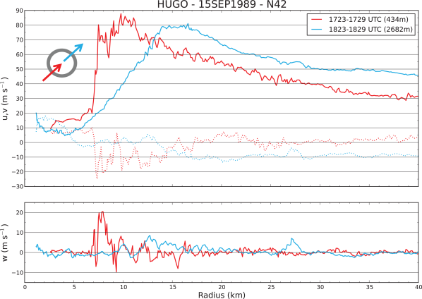
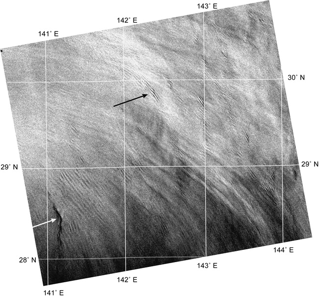
| Figure 1: NOAA WP-3D (N42RF) aircraft data from an inbound leg in the southwest quadrant (red, 434 m average height) and an outbound leg in the northeast quadrant (blue, 2682 m average height) of Hurricane Hugo on 15 September 1989. (top) The solid curves show the tangential wind component, while the dotted curves show the radial wind component. (bottom) The vertical component of the velocity. A boundary layer shock develops near the eyewall of Hurricane Hugo. See Williams et al.(2013) for more details. | Figure 2:RADARSAT-1 synthetic aperture radar (ScanSAR Wide B) image of Typhoon Fengshen showing evidence of finescale roll circulations across much of the image (e.g., black arrow). The center of the typhoon is just to the southwest of the image at 28.3 N, 140.7 E, with the signature of eyewall convection visible in the lower left of the image (white arrow). See Morrison et al. (2005) for more details. |
2. Dynamical Instabilities in Geophysical Vortices
Unsteady, asymmetric processes near and within the cores of geophysical vortices is a topic of increasing meteorological and geophysical interest. The growth of small-scale disturbances within the core of the symmetric hurricane vortex has been argued as a cause of rapid structural variability in a mature tropical cyclone and for phenomena such as polygonal eyewalls and the formation of mesocyclones. Moreover, there is growing evidence that asymmetric dynamics play an important role in both the track and intensity changes associated with tropical cyclones. Within the field of fluid dynamics, the growth of small-scale disturbances (known as eddies) at the expense of the mean flow indicates the presence of a fluid instability. My past research examined how the development of these instabilities initiates irreversible mixing within the core of geophysical vortices (such as the hurricane inner core).
|
|
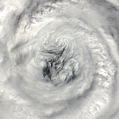
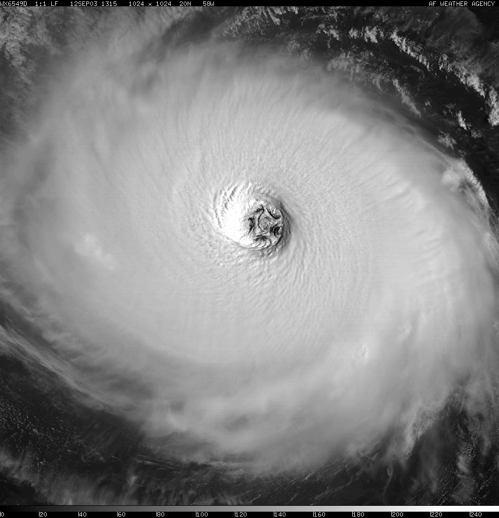
| Figure 3: A MODIS image showing a swirling pattern of eye clouds for Typhoon Nari, indicative of inner core mixing between the eye and eyewall. See Kossin et al. (2002) for more details. | Figure 4: Defense Meteorological Satellite Program (DMSP) image of Hurricane Isabel at 1315 UTC 12 Sep 2003. The starfish pattern is caused by the presence of six mesovortices in the eye (one at the eye center and five surrounding it). See Kossin and Schubert (2004) for more details. |
|
|
|
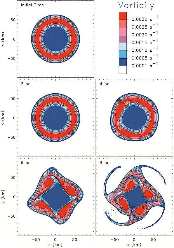
Figure 5: A numerical simulation of the inner core vorticity mixing for an annular vorticity ring up to 48 hours. Barotropic instability produces counterpropagating vortex Rossby waves that redistribute vorticity from the eyewall to the eye. See Schubert et al. (1999) for more details.
My current research extends this work by examining the evolution of fluid instabilities within mature hurricanes with double eyewalls. Intense hurricanes at times undergo eyewall replacement cycles (ERCs), in which an outer eyewall and wind maximum form at several times the radius the radius of the primary eyewall. The outer eyewall usually then contracts and intensifies, while the inner eyewall weakens, disappears, and is replaced by the outer eyewall. These ERCs have significant impact. The formation and the contraction of the outer eyewall often coincides with a weakening, or a pause in the intensification, of the storm. The formation of the outer eyewall [known as secondary eyewall formation (SEF)] is associated with an increase in the area covered by the strong winds, which leads to more severe storm surges near land. SEF is widely recognized as an important research problem in the dynamics of mature hurricanes, but as of yet there is not a consensus on the phenomenon's fundamental physics. Furthermore, recent observations have shown that SEF can initiate inner eyewall breakdown through a fluid instability process. The ultimate goal of this research is to develop a full theory of the dynamical stability of mature hurricanes using computer modeling, satellite imagery, and radar imagery.
|

|
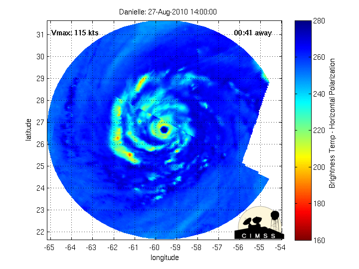
| Figure 6: An animation of the Morphed Integrated Microwave Imagery at CIMSS (MIMIC) product revealed that Hurricane Danielle (which had intensified into a Category 4 storm) was undergoing an Eyewall Replacement Cycle (ERC) during the 27 August - 28 August 2010 period. See the CIMSS Satellite Blog for more details. | Figure 7: Radar loop of Hurricane Maria approaching Puerto Rico on September 19th-20th, 2017. Notice the oscillation and breakdown of the eyewall. |
3. Physics of Vortex Merger and Vortex Resiliency
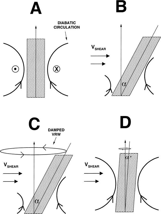
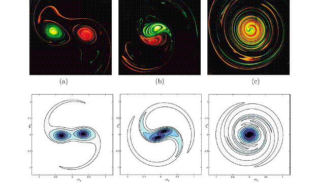
During its development, an atmospheric vortex may experience episodes of external vertical shear. A vertically tilted vortex in the atmosphere either succumbs to external vertical shear by irreversibly shearing apart or by resisting external forcings to align, a process called vortex resiliency. Recent research has shown that atmospheric vortices under weak vertical shear remain vertically upright through a self-axisymmetrization process. However, most of these studies examine weakly rotating vortices under weak unidirectional shear. My research extends this by examining the dynamics of vortex resiliency for rapidly rotating vortices under moderate directional shear. These results have relevance to the observations of vortex resiliency for mature hurricanes and severe convective storms. My research also examines the physics of vortex merger for rapidly-rotating vortices, which have applications for the dynamics of hurricane-trough interactions. The ultimate goal of this research is to show how the processes of precession and nutation for rotating rigid bdoes (as discussed in undergraduate classical mechanics) can be extended to understand the dynamical mechanisms behind the evolution of geophysical vortices in environmental shear.
|
|
| Figure 8: A schematic of the TC alignment mechanism when the TC vortex is tilted by vertical shear. As the TC vortex is tilted by the vertical shear, VRW damping counters the differential advection of the TC by the vertical shear. See Reasor et al.(2004) for more details. | Figure 9: Cross-cut experimental dye visualizations of two laminar co-rotating vortices before, during, and after merging. See Meunier et al. (2005) for more details. |
4. The Physics of Coastal Squall Line Evolution
Residents in the Lowcountry region have often noticed that squall lines often dissipate as they propagate towards the Atlantic ocean. Mesoscale convective systems that develop upstream of a large water body (ocean, sea, large lake) and move toward the coastline respond to the stable marine atmospheric boundary layer (MABL), which can propagate tens of kilometers inland as a sea breeze. The response of these storms is sensitive to the buoyancy and depth of the MABL, as well as the time of collision in the storm's lifecycle. While the presence of a stable boundary layer can contribute to storm decay, it is not always a detriment to storm survival, and at times can contribute to enhanced storm intensity. Furthermore, most regions impacted by coastal squall lines have topographic relief, such as plateaus and mountains, immediately upstream of the coast. As storms move over the variable terrain toward the coast, they respond to the resultant changes in environmental instability and vertical wind shear. Additionally, characteristics of a storm’s cold pool - a diabatically generated density current that spreads out along the ground initiating new convection and moving the storm forward - changes as it ascends and descends the sloping surfaces, impacting storm intensity and its ability to traverse obstacles.
